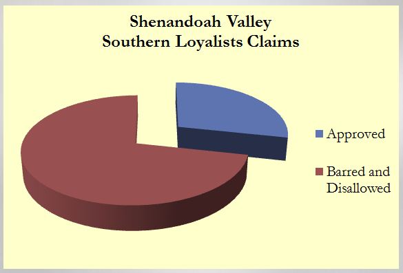
With an interest in seeing Southern Unionism from a different perspective, I’ve been tinkering with data a bit. The following pie charts are just some examples of the ways in which I’m reviewing some of the data I’ve compiled. Each illustrates the different levels of completeness for the various counties of the Shenandoah Valley.

Basic stats for the entire Shenandoah Valley, showing just the number of claims approved, and claims barred and disallowed.
Comparing these charts can be tricky. You can’t take them at face value. Rather, one must know exactly how many claimants are reflected. Take for example an effort that might compare Augusta and Warren counties…
There are also instances in which I’ve gone beyond the basic claims applicant numbers…

Rockbridge County’s stats also include the number of USCTs born in the county (though some may have not been residing in the county at the beginning of the war).

The most complex chart, at this time, covers Page County (it helps that my history grad thesis concentrated on Unionists from the county)… in which I’ve included even more than just claimants and USCTs. I’ve discovered other Unionists in various sources, from the claims records (though the “others” were not claimants themselves) to military service records of whites from the county who served in Union units. In time, all of the Valley counties will have this data.
In addition to the information considered in the different pie charts, I’m also considering other data, including physical location of the claimant at the time of the war (Google Maps will be employed for this… embracing practices exhibited by Craig, in To the Sound of the Guns), real estate values, personal property values, occupations, slaveholder/non-slaveholder Unionists and places of birth. More on some of these at a later point.
For more information about the different counties, visit this link to the Shenandoah Valley subsection of my Southern Unionists Chronicles site (which I “refurbished” in December, to serve more as a data compilation “site” than a blog). Please keep in mind… this is a project in development (even the pie charts above), and data available varies.


JMRudy
February 20, 2013
From a purely selfish standpoint, I’d love to see Jefferson County mapped. It’d be interesting to know if there’s something larger at play here than just the Federal jobs of the armory injecting cash into the equation.
Robert Moore
February 20, 2013
You’ll be pleasantly surprised, John. In addition to my work on data, my daughter is also compiling data, though specifically for Harpers Ferry, for her History Day project. More details to follow in time!
SF Watson
February 22, 2013
i’d also like to see Jefferson as well as Berkeley County results. Growing up in Jefferson County in the 1950’s and 60’s some of our older teachers were still pointing out which side certain towns in these counties had favored. And in reading some of the personal diaries of soldiers who had been in the area, it’s amazing how totally different were the perceptions of who was pro-Union or Confederate.
Robert Moore
February 22, 2013
Thanks for commenting. Jefferson and Berkeley will likely be my focus for stats posts soon. I’m tallying data now.